|
|

|
 |
| Other comments left for this publisher: |
|
|
|
|
|
|
|
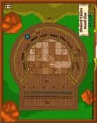
I wrote an adventure for 3rd Edition Dungeons & Dragons that was inspired by Shakespeare. It was my chance to finally put my English major to good use! To my surprise, I discovered that there weren't a lot of tiles for a theater -- apparently, your average murder hobo is an uncultured boor -- so this is pretty much it when it comes to battling it out on stage (or in the cheap seats). The design is a little bland but it worked well for the adventure.
|
|
|
|
|
|
|
|
A good and useful selection of symbols for CC3. Easily to install and to use. Even with CC3+ there are no problems.
The symbols are devided in different sections, that make the finding of the needed symbols easy.
Only the roof symbols aren't my liking, as the roofs have a fixed size.
|
|
|
|
|
|
|
|
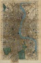
Great to get access to an old map. But I disagree with the former reviewers: the resolution of the scan could be much higher. It´s, quite o.k. for jumping from quarter to quarter, but insufficient for closing in and hunting your players character through alleys and streets. Lines, corners and letters are getting blurry than...
Just compare with the maps of London in 'The Imperial Age: London' from Adamant Entertainment, page 7+
|
|
|
|
|
|
|
|
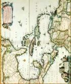
Not too bad, can read most of the names onscreen and I assume you still could if it was printed big enough (A3 still didn't come out clear enough for me). I'd personally search the net for other maps if you wanted to set a game in the Caribbean, there are a few less detailed, but more usable maps out there.
|
|
|
|
|
|
|
|
Good old maps are hard to find. This is worth the price in ease alone.
While exactly printer or monitor freindly, I would rather have high detail than something that is easy to print.
Perfect "authentic" game aid for any historical game.
|
|
|
|
|
|
|
|
Extremely well scanned map of London. We actually can see much detail such as road and place.
I've been using it for Cthulhu game. I would like to see more of these kind of maps!
The dpi are enough precise that I made it print as a laminated/poster I've but in my office.
|
|
|
|
|
|
|
A very good product. Be warned, the download is actually 11mb.
|
|
|
|
|
|
|
|
For the Three Musketeer or Swashbuckler fan, this is a reasonably useful map to have. Do not expect to zoom in for ever. There is a limit to the detail provided in the scan, just like Google Earth. An annotated Places of Interest list would have been nice, but an hour or two on the internet will unearth enough for a casual RPG encounter.
I found that the French mapping authority, I.G.N. have two scanned DVDs of maps from the countrywide survey carried out by cartographer Cassini on behalf of the king. Since most of rural France has not changed much since the 1650s, miniature wargamers and roleplayers have lots of material with which to play. The map of Paris is just the start.
|
|
|
|
|
|
|
|
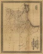
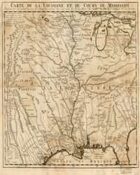
Part of the Antique Maps series by Split Eyed Productions, Mississippi River Basin of the 1700s is a large scale map of the region during the 18th century. It is presented as both a single large 4.5MB jpg, 5756px by 5659px of glorious map porn. A sliced version of the image, in nine pieces is also provided, providing for easier printing of the piece.
Now, like all good map porn, it is of most interest to game masters. It is a sepia-toned piece showing roads, rivers, hills mountains and and city, river, and region names in the original French. It identifies the territories of the Apaches and Osages, Pays Des Apache, Pays De Osages. (It was after-all, French territory until the Louisiana purchase, and held by the First nations before that.) The French place names, done in a flourished script, provide an interesting view of the territory, it would be of use to GM?s playing a historical campaign, or of course, for retelling your vampires troubled past to a newspaper reporter.
You won?t be able to run a battle on it, but it can certainly add a lot of atmosphere and inspiration for running a game. It would make a gorgeous prop as well, and you can easily print out the sliced version.
Overall, it is a gorgeous bit of map pr0n seeped in French colonial influence, unknown wilderness laying just a few steps away. So I recommend it to an Players interested in a showy bit of map porn, or GMs looking of inspiration in the 18th century French Territory.
<br><br>
<b>LIKED</b>: Map tears in piece, authentic history<br><br><b>DISLIKED</b>: A translation of map inscription would have been nice.<br><br><b>QUALITY</b>: Very Good<br><br><b>VALUE</b>: Satisfied<br>
|
|
|
|
|
|
|
|
This is a scan of an actual historic map showing a central portion of the United States circa the 18th century. The map itself is very detailed and has a nice, hand-drawn quality to it. The sepia color scheme lends an antique feeling to the product, adding to the visual effect. Map labellings appear to be written in French.
While this product is literally a map, I don't think it is very useful for the kinds of things one generally needs a map for in a roleplaying game. You couldn't, for example, use it as the overland map for a campaign. There is no key, no real scale that I can find, and everything is written in a language I don't speak. Clearly, a lot of work would need to be done to turn this into a tool with a lot of utility.
As a visual aid or source of inspiration, however, I think that this product does well. Imagine a group of players in a historical RPG set in the United States around the time of the Louisiana purchase. The PCs decide to purchase a map of the area from a local fur-trapper, and the GM hands them this as a starting point. The players could add their own details as the campaign progressed, building and expanding the map as they go. Or perhaps the map contains clues to a treasure hidden in the 1700s by a French explorer. The modern adventurers must try to follow in the footsteps of the explorer, all the while dealing with terrain that has experienced centuries of change.<br><br>
<b>LIKED</b>: This is a nice visual aid, and a creative GM will certainly find something clever to do with it. If you're looking for authenticity, you can't go wrong with an actual map conceived and created in the 18th century region it depicts.<br><br><b>DISLIKED</b>: I had problems viewing this product. The main map is too small to see in any detail, while the various zoomed-in portions showed too small a section for my tastes. The format may be ideal for printing, but it doesn't hold up as well when viewed on screen.<br><br><b>QUALITY</b>: Very Good<br><br><b>VALUE</b>: Satisfied<br>
|
|
|
|
|
|
|
An excellent purchase.<br><br>
<b>LIKED</b>: This map is beautiful and richly detailed. The file is HUGE--the detail can't all be seen on one screen. There's even points where you can tell where the map has been folded (in some pilot's logbook?). If you're playing any setting in the Carribean in the age of sail I recommend this purchase.<br><br><b>DISLIKED</b>: Makes me want to spend more money on similar maps and, I wish I had the skill in Campaign Cartographer to make something similar.<br><br><b>QUALITY</b>: Excellent<br><br><b>VALUE</b>: Very Satisfied<br>
|
|
|
|
|
|
|
|
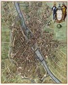
Part of the Antique Maps series by Split Eyed Productions, Paris of the 1600s is a large scale map of the city, circa 1664. It is presented as a single (Xbox is) huge jpg, weighing at 17MB, 7800px by 6532px of glorious map porn. Now, like all good map porn, it is of most interest to game masters. It is a colorful artist?s rendering type affair, even showing peasants in the field, street names in hand-drawn script. It, as is Paris, is centered on the river Seine, La Riviere De Seine, as the map informs us. So it is a gorgeous map with plenty of flavor and ?narrative? detail. You won?t be able to run a battle on it, but it can certainly add a lot of atmosphere and inspiration for running a game. That said, because it is so large, it is only suitable for printing as a poster, you would need to have it printed at your local print/copy shop to do it justice. Thus it would have been nice if the product included say 4 or 8 PDF sections of the map. A single zoomed version of the map, and then quartered pieces of the map would make it more readily useful.
Overall, it is a gorgeous bit of map pr0n dripping with atmosphere and narrative bits to inspire a GM. However, short of having it professionally printed, the GM will have to do some cutting and pasting of his own to produce something to share with the players
<br><br>
<b>LIKED</b>: street names, arty whimsical nature of it.<br><br><b>DISLIKED</b>: Could have been made more useful with a few PDF pages. <br><br><b>QUALITY</b>: Excellent<br><br><b>VALUE</b>: Disappointed<br>
|
|
|
|
|
|
|
|
Since I own CC2, any symbol packs that you can grab at a reasonal price are good and make a good/great thing better.<br><br>
<b>LIKED</b>: Everything<br><br><b>QUALITY</b>: Very Good<br><br><b>VALUE</b>: Satisfied<br>
|
|
|
|
|
|
|
|
|
|
|


![Symbols Collection 1 - The First Two Years [BUNDLE]](https://d1vzi28wh99zvq.cloudfront.net/images/bundle-thumb140.png)